|
Distance |
18.5km / 12 miles |
|
|
Explorer maps |
Leeds - OL289, Ripon & Boroughbridge - OL299 |
|
|
Time |
5 - 5.5 hours average time based on Naismith’s rule |
|
| Total ascent | 150m | |
|
Total descent
|
90m
|
|
|
Waypoint coordinates |
|
|
| Download PDF |
|
|
|
Overview |
After leaving Boroughbridge the walk passes through the village of Roecliffe, the site of two 1st Roman forts. These were located where the modern A1 ( M ) crosses the River Ure. It is believed that the forts were short lived and were abondoned in favour of the Roman town of Aldbrough, one mile to the east.
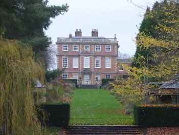
From Roecliffe leave the main road to continue along a narrow lane, often teaming with wildlife, and then head down to join the river bank. Keep left passing Newby Hall ( designed by Sir Christopher Wren ) on the opposite bank and then along Ripon Canal to reach Ripon Cathedral. Prior Richard was received here by Archbishop Thurston in 1132 before being taken to Skeldale, now the sight of Fountains Abbey and the end of the Prior Richard Way. |
1 - From Boroughbridge town return to Valuation Lane and turn left along Roecliffe Lane to the main road. Turn right passing under the motorway bridge and Bar Lane. At the last of the large industrial buildings on the left, turn left to pass the nature reserve again to reach the old railway line.
2 - Turn right and at the end briefly turn right on Thorns Lane and then almost immediately left through the field. Keep to the right and through somebodys garden ( this is a public footpath ) to reach the village green in Roecliffe. Cross over the green and turn left past the public house and out of the village. After the road bends left, turn right on Sheaflands Lane, this is beautiful narrow tree / hedge lined lane often teaming with wildlife. Eventually the lane becomes grass with a small wood on the right. At the end turn right diagonally down to the river bank.
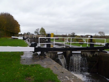
3 - Follow the river bank all the way to the canal lock. Pass it with it on the right, this is a small cutting for the canal boats to avoid the river weir. Continue ahead where some of the next fields can be boggy in places. Pass Newby Hall on the opposite bank to reach a small tarmac road. This area used to be an old military camp. At the road turn right where there maybe barges out of the water being repaired.
4 - Continue ahead with the River Ure on the right to Oxclose Bridge, keep to the left of it and follow the Ripon Canal to Rentons Bridge. At Rentons Bridge turn right to cross the canal ( don't fall in ) and then left to walk on the opposite side of the canal bank. Pass Nicholson’s Bridge on the left, Ripon racecourse on the right and the nature reserve and hides, a good place to stop and admire the birds that gather annualy at this resting point.
5 - Continue ahead past Lock House and under the road bridge to the end of the canal. Cross briefly into the carpark and turn right to the road and turn right again ( Bondgate ) and then left along Firs Avenue to cross the wooden bridge over the River Skell and down Low Saint Agnesgate.
6 - Turn left along High Saint Agnesgate with the cathedral burial ground on the right. After the small building on the right ( green information plaque ), turn right along the lane ( Information plaque on the left ) through the cathdral gate and left to reach the main entrance
7 - With the Minster behind you turn left along Bedern Bank and across the roundabout into King’s Street crossing the River Skell. Immediately turn right along the river pathway and at the road continue ahead on Barefoot Street and then bear left on Harrogate Road, direction Harrogate A61.
8 - Take the next left Borrage Green Lane and inbetween a lampost and telegraph pole turn left along the narrow path to reach a large field. This section can be a bit tricky to navigate but all the paths lead to the same place eventually. Cross the first field heading to the right corner and into the next field and ahead to cross it to the third field. In the third field bear left to reach an old railway line, this used to be the old station and is an easily defined cutting.
9 - At the path t-junction turn right through a gate and after passing a large house on the left of the path arrive at a path + junction. Turn left to reach the village of Studley. Cross over the road and into the deer park.
10 - The path naturally bears diagonally left down to the main estate park road. Look left to see Ripon Cathedral. Turn right towards the large obalisk at the top of the road and at the cross road turn left down to Studley Royal Water Park and the entrance to Fountains Abbey and possibly stop for some refreshments at the cafe before entering the Abbey. There are public toilets on the right in the carpark.