|
Distance |
4.6km / 2.8 miles | |
|
Explorer maps |
Galashiels, Selkirk & Melrose OS 338 | |
|
Time |
1 - 1.5 hours average time based on Naismith’s rule |
|
| Total ascent |
177m
|
|
| Total descent |
147m
|
|
|
Waypoint coordinates |
|
|
| Download PDF |
|
|
|
Overview |
This is an pleasant and short route from the main street of Newtown St Boswells, along the River Tweed and onto the old main road to Melrose, past the Rhymer’s Stone to end the stage at Melrose Abbey. |
 1 - From the main street opposite a green field turn right onto Hamilton Place and right at the T-junction along the Croft. After passing the second lamp post on the left bear left with a hedge on the right and then left with the River Tweed on the right. The path continues above the river and then descends to reach a road. Turn left away from the suspension bridge and then right up the steps following the Borders Abbey.
2 - The track passes under the A68 to then reach a T-junction and a red bricked single height building on the right. Turn right on Tweeside road to the main road and turn right again to leave Newtown St Boswells. Turn left on the road and National Cycle route 1, blue cycle sign - Melrose 2.5 miles.
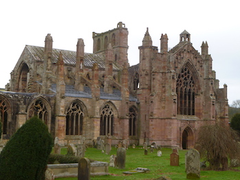 3 - Continue onto the gated road, the old main road, and past the Rhymer Stone on the right to reach the A6091. Turn left and then right, signed Melrose to the roundabout. Turn right to reach Melrose Abbey and the end of the stage.