
|
Distance |
27.1km / 16.8 miles |
|
|
Explorer maps |
Leeds - OL289, Ripon & Boroughbridge - OL299 |
|
|
Time |
6.5 - 7 hours average time based on Naismith’s rule |
|
| Total ascent | 161m | |
|
Total descent
|
222m
|
|
|
Waypoint coordinates |
|
|
| Download PDF |
|
|
|
Overview |
This is a very pleasant and easy walk from the west side of Fountains Abbey. The route follows parts of the Ripon Rowel Walk and the Knaresborough Round through fields and woods, along paths, tracks, green lanes and minor roads.
South of Markington village pass Wallerthwaite, a medieval village deserted by the 14th century, it is thought that the Black Death in 1349 and raids by the Scots earlier in the century were responsible for it's demise.
Continue through the medieval villages of Ferrensby and Arkendale, and then walk parallel to the Roman Road of Dere Street before reaching Whixley and the end of the stage |
1 - With the west gate of Fountains Abbey behind you turn left along Fountains Lane crossing over Fountains Bridge and the river Skell. After passing the S bend sign on the left, the road bears left, continue straight ahead past Ninevah house to reach a footpath. Follow the footpath sign to the far right corner of the field which can be very boggy. Cross diagonally right over two more fields to reach Whitecliffe Lane.
2 - Turn left along the lane, pass under the telegraph wires, at the third telegraph pole on the left, turn right through the metal gate. This is a permissive path to avoid walking through Morcar Farm. Keep the hedge on the left and at the field corner pass into the next field continuing ahead again with a hedge on the right. Rejoin the original path to reach a gate at the entrance to Strait Lane, this is carpeted in Bluebells in spring.
3 - Pass through the gate and immediately turn right to cross the stile into the field. This was planted with Christmas trees at the time of writing these stage notes. Bear left to reach the middle of the left side of the field and a track. Continue along the track to a T-junction. Bear slightly right to cross a stile ahead into a field, continue with the hedge on the left to Yarrow Hill farm. With farm buildings on the left bear right into and across the field to a stile in a wall and a small lane. Turn right and almost immediately left through the hedge and the trees and then between a wall and the side of a house to the corner of a road in Ingerthorpe.
4 - Continue ahead and immediately turn right through the wooden gates following the Ripon Rowel Walk signs to Western Lane in Markington. Turn left at the lane and at the crossroad continue ahead briefly along Back Lane, where it bends right keep ahead again following the Ripon Rowel Walk sign to the road. Cross the A61 and turn right and then immediately left in front of the electricity pylon. Turn right across the field to Church Lane and turn left to leave the village of South Stainley.
5 - Pass Stainley Hall on the left and where the lane bends right keep ahead to continue on Stainley Lane. After two fields turn left onto Rakes Lane. Where the lane bends left down towards houses, leave the Ripon Rowel Walk and continue ahead to crossing over a cattle grid to a
T-junction. Turn right onto Green Lane and where the lane bends right continue ahead on the green path to reach a path cross road at the bottom of a small hill. Turn left passing between hedges and Walkingham Hill Farm and at the bottom of the drive a road T-junction.
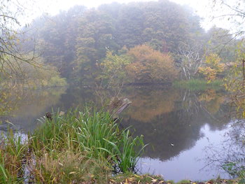
6 - Turn right on Occeney Lane to the T-junction. Turn right on Copgrove Lane past the houses on the right and turn left into the field by double telegraph poles to follow the Knaresborough Round path. Halfway up the field turn right through a hedge into a field and then turn left keeping a hedge on the left, continue round the field, across a disused railway line and past a large pond on the left to reach a small bridge. Cross over the bridge and turn right and keep ahead to the road on the edge of Ferrensby
village.
8 - Turn right and then left at the Farm shop onto the old A61, now a Bridleway. After the metal barrier take the second left onto a small tarmac lane between trees. With a house ahead turn left and then right to a
T-junction. Turn right and at the end of a wooded area on the right where the track bears right, continue ahead to the left of a green hedge to a track and T-junction (on the left opposite the hedge and across the field is a wooded area).
9 - Turn right. At the end of the first field on the left, turn left to walk between the fields. At the end bear slightly right and ahead through the hedge and straight ahead passing High Farm on the left continuing along Ox Close Lane which becomes West Lane. At the T-junction bear right continuing on West Lane which becomes Church Street and pass a Minotaur on the left, it won't bite.....honest! At the T-junction turn right onto High Street and Whixley village and the end of this stage.