|
Distance |
Route 1: 31.2 km / 19.3 miles Route 2: 31.6 km / 19.6 miles |
|||
|
Explorer map |
150 Canterbury & the Isle of Thanet | |||
|
Time |
Route 1: 7.5 - 8 hours average time based on Naismith’s rule Route 2: 7.5 - 8 hours average time based on Naismith’s rule |
|||
| Total ascent |
Route 1: 258m Route 2: 303m |
|||
| Total descent |
Route 1: 264m Route 2: 306m |
|||
|
Waypoint coordinates |
Route 1: Route 2: |
|||
| Download PDF |
|
|
||
|
Overview |
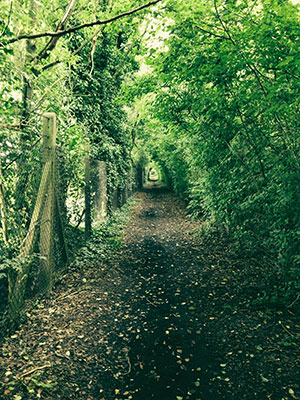
The route follows the North Downs Way all the way to Dover or an alternative more direct and scenic route via St Radegund’s a Premonstratensian Abbey 1191, now partially ruined. |
Route 1 - North Downs Way:
Route 2 - St Radegund’s:
 1 - From the Cathedral head back towards the Butter Market and turn left along Burgate to the main road. Cross the main road to Church Street and turn right at the end along Monastery Street / Longport past St Augustine’s Abbey. At the roundabout continue ahead on Longport and then right on Spring Lane and then right again - this is now the North Downs Way. At the end pass through the housing estate following the signs Pilgrims Way. At the end continue ahead into the field on the NDW to reach the village of Patrixbourne. At the mini-roundabout keep right along The St. Follow the road round into Patrixbourne Road past the church and after the last house on the left turn left NDW. The path will eventually run parallel with the A2 on your right briefly and then to Womenswold. Pass through the village continuing on the NDW to the village of Shepherdswell.
There are now two optional routes to Dover from here:
2 - As the path enters Shepherdswell cross over the railway line and turn left FP to pass through several fields before travelling along Moon Hill. At the end turn right and immediately left FP & North Downs Way. Continue following the NDW crossing the A256 to reach the village of Ashley. Pass through the village continuing on the NDW to travel along the Roman Road through the village of Pineham to reach Dover. Cross over the disused railway line and at the end of the old road turn left to cross the road following the sign to the recreation ground. This will take you up a path with a metal railing in the right giving protection from the road to reach Connaught Road. Cross over and along Park Avenue to the end. Turn left along Maison Dieu Road to pick up and follow the visitor information signs.+
2 - As the path enters Shepherdswell cross over the railway line and turn left FP to pass through several fields before travelling along Moon Hill. Turn right on Mill Lane and then left by the village green with it on your right leaving the NDW. At the end turn left Coldred Road and after the last house on the right, turn right up the steps and into the field. Cross diagonally over two fields to reach a track. Cross over and continue to the hamlet of Coldred Street turning right onto Coldred Road. Continue to Coldred Hill and where the road bears right out of the village head slightly left to pass farm buildings and Parsonage Farm House on the left. At the end of Caens woods turn right crossing diagonally to the A2 road. Cross over taking care to the footpath opposite. Cross the field to the right corner of the copse and then turn left to keep it on the lefthand side to reach the end of the field with a small strip of trees / hedge on the left. (This runs at 90 degrees to your position) The path now follows the righthand edge of the field and then turns right to skirt round a ridge. Several paths lead off from this take the middle one ahead towards the houses not the allotments. At the end turn right to reach the road.
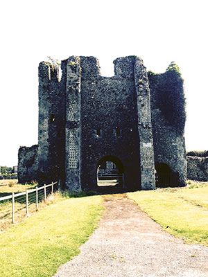
3 - Cross over the road and into High Street which becomes Lower Road. At the junction with the main road turn right to head along Alkham Road. After passing a large house on the left, reach the end of the woods and turn left to enter the field. Continue ahead to cross it turning right to follow the field boundary to reach a gate. Pass through he gate and take the path that leads diagonally right through the woods to eventually reach the road. Turn right and continue across the junction to St Radigund’s Abbey Farm. Pass the Abbey gatehouse and round towards the back on the farm complex and on the corner of the bend, head straight across the field. After the second one reach a track the path bears right around Gorse Hill to Poulton Farm.
4 - Pass through the gate on the left before the farm buildings to reach Coombe road and turn left and as the road bears left take the footpath slightly right and straight ahead into the wood not right and around it. Cross the field and turn left and continue ahead ignoring the path off to the right. The path follows the boundary of Long Wood and along the ridge of Whinlass Down and to the right of the school building to reach Kings Road. Turn left and continue to the end to reach Vale View Road. Turn right and then left to the roundabout and turn right onto York Street and the third left Queen Street to reach the Tourist Information Centre