|
Distance |
40.2km / 24.9 miles |
|||
|
IGN map |
GR Top100 map - 101 Lille Boulogne-sur-Mer |
|||
|
Time |
9.5 - 10 hours average time based on Naismith’s rule |
|||
| Total ascent | 445m | |||
| Total descent | 415m | |||
|
Waypoint coordinates |
|
|||
| Download PDF |
|
|
||
|
Overview |
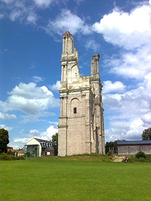
The stage starts on the old railway line before then following a more direct route closer to Sigeac’s path on fairly level ground. From Ecoivres (4) there is the opportunity to walk to Ablain-Saint-Nazaire but this route continues to Arras saving an additional 12km to the total dis-tance. It is worth the short distance to visit the Abbey of Mont Saint Eloi which can be seen on the horizon (see photo).
From Ecoivres continue on minor roads and tracks before entering Arras and following cycle tracks by the main road, passing through the park of Les Grandes Prairies. Continue by main roads to the centre of Arras. |
1 - From Bruay centre walk down Rue de Republique, downhill back to the crossroads, past the petrol station on the right, and left up Rue Chopin. Continue past the old miners houses, and left at the top of the hill. Go down the steps at the end of the road, down the next road and then right on the main road. Take the next right opposite Rue des Pyrenees to walk past the Intermarche this time on your left. This route returns to the route of the old railway line by staying on the right side of the path to pick up the GR145 VF. Continue along the old railway line and cross over 2 roads. At the third road turn left up it and along Chaussee Brunehaut. Cross the roundabout to continue along the road, ignoring the GR145 path on the left. At the third STOP sign turn right direction Hermin (D72). Take the track right towards the water tower and left at the road to the centre of Hermin. The road will go down Rue De Chateau and then turn right before the church Rue Basse. Continue ahead and then keep left Rue De Calvaire to the main road and straight on to Caucourt (D73).
2 - At the village of Caucourt take the first left before the sign, carry on over the stream, turn right and then next left at the main road to leave the village. After approx 1k take the small road on the left, keep right, and then after approx 2.5k turn left into the village down Rue De Villiers-Chatel. Carry on across the road D73E2, direction Camblain - L’Abbe. At Camblain - L’Abbe turn right at the next junction ignoring the left turn past the church to take the next left Rue Cojon. Then take the second left Rue D’Acq, and then turn right at the junction. After this turn left before entering Frevin Capelle.
 3 - Follow the road keeping left to Acq, and then straight across at the next junction - this will even-tually become a farm track which will then reach a road. Turn left on this road to the village of Ecoibres. Carry straight on where the road bears right (FFRP marked). Keep right along Rue JB Obeuf and then bear right continuing on this road to arrive at Place De L’Eglise in Ecoivres.
4 - At Place De L’Eglise there is the option to turn left turn left to visit the Abbey of Mont Saint Eloi which can be seen on the horizon (see photo) but the route goes right following the road round on Chemin Des Nomands, then next left to the village of Bray. In Bray turn right along Rue De L’Ecole to cross the railway line and then the track left (VRF145). Turn left over the railway crossing and bear right to Maroeuil centre, and then right at the junction (red house on the left and footpath sign on the lamp-post). Turn left at the end and cross over the La Scarpe, then turn right Rue De La Marliere. Take the next right Rue De La Source to eventually pass through the car park and then path left before crossing the river.
5 - Turn right into Lovez, then right direction Military Cemetery and then left along Rue Des Macons and the Military Cemetery. 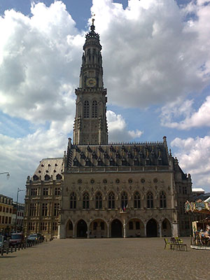 Continue ahead under the road and where the track passes between new houses bear left at the junction. Go straight on, down the steps and right and right again on the main road. Cross over Rue Nelson Mandela and after 1k turn left direction Les Grandes Prairies. Turn immediately right through the car park and gravel path, turn left at the junction and follow the road bearing right. After the basket ball courts on the right take the next right to keep them on the right side. Go straight ahead to cross the bridge and left and then soon right and up the steps to the main road.
6 - Turn left and follow the Arras Centre Ville sign on Rue Baudimont, then Rue Saint-Aubert. Reach the Banque De France on the right, take the left road Rue Desire Delansorne to the bell tower ahead, and then right to Place Des Heros.