|
Distance |
29.3km / 18.2 miles |
|||
|
IGN map |
GR Top100 Map - 103 Amiens / Arras |
|||
|
Time |
7.5 - 8 hours average time based on Naismith’s rule |
|||
| Total ascent | 271m | |||
| Total descent | 220m | |||
|
Waypoint coordinates |
|
|||
| Download PDF |
|
|
||
|
Overview |
This route continues along roads, tracks and an old railway line which may be a bit over grown, but is passable. Accommodation is very limited in Bapaume but would make the distance shorter if found. |
 1 - From Place Des Heros in the centre of Arras with the Tourist Office behind you head towards the right hand corner of the square, and turn right to Rue Balances. At the end turn left, then right Rue Briquet Tailliandiers and finally left Rue Gambett heading towards the railway station. Turn right to pass the Holiday Inn Hotel on your right side and then left over the railway line along Avenue Du Marechal Leclerc which will lead into Avenue Fernand Lobbedez. Continue down the main road for approx 3km and then right by the Nouvelle Auberge on the corner of Rue Robespierre. After approx 4km ignore the left turn but continue ahead through the village of Mercatel and then across the junction to pass underneath the TGV railway line. Pass the Montaigu Chapelle (Sunken Road cemetery), and then come to a T-junction at Camblain-l’Abbe and turn right.
 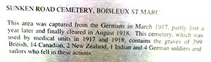 Pass under the first set of power lines, take the left path into the woods, and then up the steps onto the disused railway line. Cross over two roads and at the third road turn right and continue on the track keeping left at the T-junction. Turn left at the next junction, up the slight incline to pass the chapel on the right.
2 - At the D12 road continue across on the track and then left at the t-junction on the road. Cross straight over and then take the next left. Turn right on the road and then next left to reach the vil-lage of Gumiecourt. At the T-junction in the village turn right, then immediately left to pass through the village and then left at the next T-junction.
3 - Before the cemetery on the left, turn right along the track. This continues ahead to pass by large barns on the left and right. At the road, continue straight on and then left at the next road to enter the village of Sapignies. Turn right just before the church and then across the road and straight on. At the next junction turn left onto the road and then right with a small chapel on your left. At the end of the track turn left, then right on the main road D929 and after crossing the rail-way line turn left. At the next cross roads turn left, right along Rue Oribus, and then left for 200m to reach Rue Peronne and the centre of Bapaume.
4 - There is only 1 hotel offering accommodation in Bapaume, and the opening times are extremely sporadic. There is a Chambre d’Hotes in Beugny which is Pilgrim friendly, and an additional 4km. The next stage stage starts from Beugny. Turn right on Rue Peronne, and then left on the D930 direction A1. Continue straight on, and Beugny is the 2nd village. This can be a very busy road.